Historical Background 1911-1944
As destructive as World War I was in other parts of the world, the Mariana Islands were spared. Still, the end of the war had important ramifications for the islands. The League of Nations approved Japan’s occupation of the Mariana (sans Guam), Caroline, Marshall, and Palau Islands in 1921 with the stipulation that Japan not develop fortifications in the region. For over a decade Japan complied with the agreement and focused on infrastructural development that strengthened the economy of their possessions.
Increasingly militaristic and expansionist, Japan sought to strengthen its presence in the Pacific in the late 1930s. For example on Saipan, Aslito Airfield on the south end and a seaplane base at Flores Point (northeast of Garapan) were constructed. Barracks, ammunition storage, air raid shelters, and other facilities preparatory for an offensive war were installed elsewhere on Saipan in 1941 (Russell 1984). Eventually Japan’s moves to fortify the islands abrogated their agreement with the League of Nations thus losing their legal jurisdiction.
The Mariana Islands in WWII, 1941-1945
Across the Pacific, word spread that war was coming, however, only the Japanese knew when and where it would start. Shortly after the 7 December 1941 attack on Pearl Harbor in Hawaii, the Japanese initiated air attacks over Guam as well, which they had been openly monitoring since November. Commercial airline buildings, fuel supplies, the U.S. Navy yard, vessels in Apra Harbor, and the capital of Guam, Hagåtña (in English Agana), were bombed. Poorly defended by the U.S., Guam fell on 10 December within six hours of the subsequent Japanese invasion. Guam thus became the only fully-inhabited part of the U.S. to fall under enemy occupation during WWII. With this prize under its belt, the Japanese Imperial Army and the Imperial Japanese Navy (IJN) mounted aggressive operations with successes across the Pacific in the early years of the war (Rogers 1995; Rottman 2004a).
As these events were occurring, Allied powers meeting in Egypt agreed upon a Pacific strategy consisting of two offensive drives. The first, led by General Douglas MacArthur, would advance from New Guinea to the Philippines. The second, led by Admiral Chester Nimitz, would push through the Gilbert and Marshall Islands across the Central Pacific to take the Marianas. From this point a strategic bombing campaign could be mounted against the Japanese mainland. By the start of 1944, this broad strategy proved successful for the U.S., and the Japanese administration realized an invasion of the Marianas was imminent. As Marine historian O.R. Lodge wrote, “A strangling noose was tightening around the inner perimeter guarding the path to their homeland” (Lodge 1954).
Operation Forager
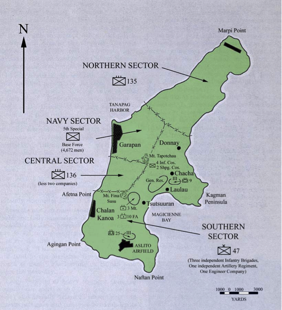
The U.S. plan to take control of the Marianas from the Japanese was code-named “Operation Forager” and included the island of Guam. The plan to invade and take control of Saipan was called “Operation Tearaway.” This massive operation involved thousands of troops from all branches of the military and a bewildering number of vessels, vehicles, and weapons. Japan defended five islands in the Marianas: Guam, Rota, Tinian, Saipan, and Pagan. Saipan, home of the administrative center of the Japanese Marianas, was chosen as the first target with Tinian and Guam as secondary. U.S. war planners opted to bypass a full assault on Rota and Pagan (Rottman 2004a).
Air attacks by Mitscher’s Task Force 58 were the first phase of Operation Forager. In February 1944, U.S. bombers attacked Guam, Saipan, Tinian, Pagan, and Rota. The mission of this force was to destroy Japanese air power, cripple lines of communication and gain photographic intelligence in the Marianas (Farrell 2009:277). The bombers destroyed a total of 168 Japanese aircraft in the air and on the ground at Orote Air Field (Guam), Sinapalo (Rota), Ushi (Tinian), Aslito Airfield (Saipan), and the base on Pagan (Morrison 1968:155). In response, the Japanese prepared “Operation A-Go,” which relied upon the support of the IJN and air forces to support troops on the ground in the Marianas.
U.S. forces again attempted to gain as much information about the island and Japanese forces by flying reconnaissance missions on 18 April and 29 May 1944. These missions collected aerial photographs of Japanese troop defensive measures and weaponry (Goldberg 2007:23). Unfortunately, the photos led U.S. intelligence to believe that there were far fewer numbers of Japanese soldiers, which caused greater resistance than expected when the ground invasion began. Additional reconnaissance work included underwater demolition teams (UDT) whose mission it was to record the depth of the lagoon to determine which vessels could be used during the invasion (Kauffman 1986:237).
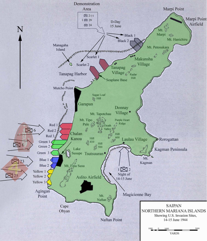
Operation Forager was in full swing by June 1944 when the invasion of Saipan was planned. The invasion was set for 15 June, “D-Day in the Pacific.” Responsible for this task was the Marine V Amphibious Corps (VAC) that consisted of the 2nd and 4th Marine Divisions, the 27th Infantry Division (Army), and the XXIV Corps Artillery (Army). U.S. military planners considered landing points on all sides of Saipan. On the eastern side of the island, an area designated Brown Beach on the Kagman Peninsula was considered but rejected because it was well-defended and would offer a poor exit. Three other beaches, Purple Beach on Magicienne Bay and White Beach 1 and 2 near Cape Obyan on the southern reach of the island, were kept as alternates. At Tanapag Harbor were the well-defended Scarlet Beaches 1 and 2 and, to the north of this area, were Black Beaches 1 and 2, which offered insufficient space for the large unit landing that was planned (Rottman 2004a).
The lower western side of Saipan was chosen as the primary invasion area. Stretching approximately four miles and divided into several zones, this area was most favorable because the size would allow two Marine divisions to land simultaneously. A landing here also allowed the immediate capture of the airstrip at Chalan Kanoa placing direct pressure on nearby Aslito Airfield. Once secure, these air strips were used to support the penetration northward across Saipan. Afetna Point divided the landing beaches. To the north were Red Beaches 1, 2, and 3 and Green Beaches 1 and 2 while to the south were Green Beach 3, Blue Beaches 1 and 2, and Yellow Beaches 1, 2, and 3 (Rottman 2004a).
As favorable as the lower western side of Saipan was for the U.S. invasion, certain limitations remained. Because of its distance from the northern sector of the island, beaches in this area (Scarlet 1 and 2 and Black 1 and 2) had to be captured in order to facilitate the off-loading of supplies from landing craft. Another problem at the beaches off the lower western side of Saipan was the extensive coral reef that abutted the shore. These had to be negotiated with the largest use to date of amphibious vehicles including AMTRACS or Landing Vehicle Tracked (LVTs) and amphibious tanks, also known as Landing Vehicle Tanks (LVT (A)s). Both the 2nd Marine Division and the 4th Marine Division had three AMTRAC battalions each, plus one amphibian tank battalion, for the initial shore assault. This amounted to approximately 1,400 AMTRACS. Once ashore, the AMTRACS had to push inland from the beach, a tactic that was equally unprecedented and also potentially dangerous because AMTRACS, with their thin armor and low ground clearance, were not designed for cross-country movement or heavy fire (Farrell 2009:297).
Japanese Defenses on Saipan
The Japanese defensive strategy employed for Saipan and the other Mariana Islands was identical to that of earlier battles at the Gilbert and Marshall Islands: the enemy was to be met and destroyed at the beaches and, if allowed inland, they were to be pushed into the sea by way of counterattacks (Denfeld 1992). Unfortunately for the Japanese, defenses on Saipan, while substantial, were incomplete by D-Day. Prior to the outbreak of the war, Japan’s need for troops and material elsewhere in the Pacific hampered the pace of developments on Saipan and the other islands of the Marianas. The Japanese forces established two bases on Saipan by early 1944. The airfield at Aslito (built in the 1930s) served as a repair and maintenance facility for aircraft involved in battles to the east and south. At Tanapag Harbor, a naval base served as a staging area for troops and ships bound elsewhere (Denfeld 1992). Due to needs in other parts of the Empire, Japanese troop numbers were fairly low and in February 1944, there were only 1,500 troops on Saipan.
The impending U.S. campaign against the Marianas hurried Japanese defensive measures and by the end of February thousands of troops were sent to the Marianas to prepare for battle. U.S. submarine attacks on Japanese transports prevented an estimated 2,000 troops from reaching the islands (Denfeld 1992). However on Saipan, some 30,000 troops were prepared for battle by early June (Rottman 2004b).
Once they had sufficient troops and materials available, the Japanese forces commenced defensive improvements on Guam, Tinian, Rota, Pagan, and Saipan. On Saipan, another airfield was built by Lake Susupe near the town of Chalan Kanoa, but this was little more than an emergency landing strip. More airstrips were planned on Saipan and throughout the islands, but most were never completed (Denfeld 1992). Forty-six gun installations were established on the beaches and ridges of Saipan, but twelve were not operational on D-Day. An additional three units lay on railcars awaiting installation at the start of the battle and another 42 were in storage at the navy base at Tanapag. Construction of three blockhouses on the beaches of Saipan, each a concrete structure with four ports housing heavy guns, began in early 1944. Between Cape Obyan and Agingan Point (White Beach 1), one of these blockhouses stood incomplete and unarmed on D-Day. Another was located to the east of Cape Obyan (White Beach 2) and the third was on the eastern side of the island at Magicienne Bay (Purple Beach) (Denfeld 1992). Japanese military leaders believed that an invasion was due in November, and even though Japanese troops had quickly erected pillboxes, blockhouses and other forms of fortification, much of their artillery was not ready for battle when U.S. forces approached in June. Nevertheless, Japanese troops intended to use the natural defense structures of Saipan, including caves and rock formations, to their advantage and were quite successful in this approach (Goldberg 2007:36).
To comprehend the intensity of the fighting on Saipan, it is necessary to understand the topography and climate of the island. Approximately 22 kilometers long and 8 kilometers across, the topography consists of a central chain of mountains running north-south along the island’s interior (Russell 1994:1). The mountains yield to a narrow strip of flat coastal land along the western side paralleled by a reef. Conversely, the eastern and southern coasts of Saipan are framed by high rocky cliffs, which drop vertically into the surf. At the time, the lowlands were a combination of swamps and sugar cane fields that not only impeded travel, but also allowed Japanese troops to ambush U.S. troops (Chapin 1994:6). Sitting on the latitude 15º 12’N, the tropical marine climate in Saipan is warm year-round with a wet season from April to October and a dry season from November to March (Department of Community and Cultural Affairs 2004:2). Fighting in June, the troops in the Battle of Saipan would have likely been exposed to daily rainstorms and forced to cope with extremely wet and muddy conditions.
The Battle of Saipan – Operation Tearaway, 1944
An intensive barrage presaged the beach invasion foreshadowing the massive confrontation that was set for 15 June. On 11 June Mitscher ordered all four carrier groups to launch their planes and attack the Marianas. A total of 208 fighters and eight torpedo-bombers flew that afternoon (Tilllman 2005:55). Two Avengers guided 58 Hellcats from the carrier USS Enterprise for an attack on Saipan. After 98 minutes, they bombed Japanese aircraft on Marpi Point Airfield, Aslito and a dirt runway at Chalan Kanoa and took on Japanese Zekes(Mitsubishi Zeros A6Ms), Kawanishi flying boats (Emily), and any other aircraft in the air (Okumiya and Horikoshi 1956). The U.S. pilots counted 98 kills while the Japanese reported 22 (Tillman 2005:62). Also caught in the attack was the Japanese ship Bokuyo Maru, which was purportedly sunk in Tanapag Harbor, and Keiyo Maru which was damaged so badly it had to be beached (Farrell 2009:291).
The next day on 12 June, 22 more kills were reported by U.S. pilots prior to turning their attention to shipping and military installations on land. Bombs were dropped on shipping facilities and other strong points and sugarcane fields were cleared with incendiary bombs (Farrell 2009:291).
On 13 June more Japanese planes were shot down including Betty and Helen bombers but the Japanese antiaircraft gunners on Saipan and Tinian also scored kills against the VT-16 Torpedo Squadron from the USS Lexington (Avengers).
Also on 13 June, seven U.S. battleships leveled the towns of Chalan Kanoa and Garapan and on 14 June, more battleships as well as 11 cruisers and 26 destroyers attacked Japanese coastal defenses. “During the first day of action, seven battleships and 11 destroyers fired over 15,000 rounds of 16-inch and five-inch shells at military targets along Saipan’s western coast” (Russell 1984:88). The 16-inch shells were the largest ship ammunition the U.S. Navy had at the time at 1.5 meters long and weighing up to 1,225 kilograms (Farrell 2009:303). As a result of this bombardment, roughly 150 Japanese aircraft were destroyed (Wheeler 1983:244). This had a significant effect on Japanese forces preventing an air attack on incoming U.S. troops.
“The din robbed us totally of all sense of hearing,” wrote Maashi Ito, a Japanese soldier, in reference to the bombardment. “It wasn’t the same as a boom or a roar that splits the ears: it was more like being imprisoned inside a huge metal drum that was incessantly and insufferably being beaten with a thousand iron hammers.” Another Japanese soldier recalled the “extreme intensity of those flashes and boiling clouds of smoke…the area I was in was pitted like the craters of the Moon. We just clung to the earth in our shallow trenches….half buried” (Rogers 1995; Russell 1994).
On 14 June, other crucial preliminary actions took place along the coast of Saipan. Early that morning, two UDTs consisting of 96 men each (specially trained Seabees) began their mission to demolish reefs, enemy mines, and mark lanes along the Red, Green, Blue, and Yellow beaches (Goldberg 2007:55). They placed light metal landing buoys parallel to the reef to help guide landing craft to the beaches (Farrell 2009:294). This effort was largely successful in clearing the way and marking the course for an amphibious invasion.
Simultaneously, a mock attack, really a diversionary tactic, was held off the northwestern coast at Scarlet and Black beaches in an attempt to trick the Japanese into thinking that the invasion was to occur there. Another was held in the early morning hours of 15 June, D-Day. The Demonstration Group consisted of the 2nd Marines, the 1st Battalion, 29th Marines, and the 24th Marines. The feint was supported by naval gunfire as landing craft approached the beach to within 5,000 yards, circled for a few minutes, wheeled about, and returned to their ships. Troops did not disembark, the landing craft drew no fire, and no activity was observed on the shore. Although clearly not convinced by the ploy, the Japanese stopped short of removing troops from here and redeploying them to other beaches. Interestingly, Japanese commanders did wire Tokyo to report that they had repelled an invasion in this area (Rottman 2004a).
As the sun rose on 15 June, the enormous U.S. amphibian force was assembled for the invasion. LVTs and DUKWs were unloaded and LSDs (Landing Ship, Dock) launched LCMs (Landing Craft, Mechanized), vessels that held tanks. Battleships, cruisers, and destroyers closed in on the invasion beach with aircraft streaming overhead toward the shore. With nearly 1,500 vessels in all, this great unpacking of troops, weaponry and ammunition would surely be an intimidating sight for the Japanese forces. At exactly 0830 hours, the LVTs carrying hundreds of marines headed for the beach as supporting ships and aircraft opened fire. A series of colored flags were arranged offshore to indicate when U.S. forces entered the range of Japanese shore defenses. The Japanese forces generally held their fire until the LVTs reached the lip of the coral reef when they poured artillery, mortar, and machine gun fire on the Marines.
Due to the condition of the seas, the Marines had a great deal of difficulty reaching the beach. Numerous LVTs were rendered inoperable or destroyed as a result. Dozens of Marines lost their lives when LVTs were overturned in the rough surf, but by 0900 hours nearly 8,000 Marines were ashore (Crowl 1960; Rottman 2004a).

Awaiting the arrival of the invading Marines were over 32,000 Japanese troops, double what the U.S. had anticipated (Spector 1984:302). Forty-eight tanks and a complex network of artillery positions supported the Japanese infantry. The strength of the undersupplied Japanese soldiers was compounded by their commitment to die for the Emperor, if need be. A force with such a mindset is a formidable one and the ensuing battle proved to be one of the most brutal in the Pacific Theatre during WWII.
The beaches, especially the northern Red and Green Beaches, were chaotic and crowded. Because of the heavy swell and long shore current, the U.S. landing in this area was several hundred yards north of where it was intended. In all areas Japanese fire was very heavy and came from the high ground as well as trenches and spider holes along the immediate shoreline. The overland LVT charge, a calculated risk, proved disastrous as the flimsy LVTs became stranded in marshy areas, craters, and other obstructions on the ground. As casualties for the Marines mounted, many chose to abandon their machines in favor of walking or crawling. Problems increased as the morning wore on. At the northern beaches, two 2nd Marine Division command posts were destroyed, killing battalion commanders and key staff and on the south, the 4th Division indecisively struggled with Japanese tanks for hours. The arrival of U.S. tank battalions, howitzer batteries, and other support forces improved the overall situation by the end of the day, although the beachhead remained unconsolidated. On this day, the first of the battle for Saipan, some 2,000 U.S. Marines were lost. Mortar and artillery fire were the principal causes of death. Offshore hospital vessels were completely overwhelmed and wounded men were transferred to other, non-hospital ships for treatment (Crowl 1960; Rottman 2004a).
Over the next two days, the Marines secured and expanded the beachhead. The morning of 16 June was spent closing the gap between the two divisions, which were separated by a strong Japanese force on Afetna Point. By noon, this goal was accomplished. A huge Japanese counterattack was successfully repelled that afternoon and the Marines engaged in the largest tank battle of the Pacific War. Aslito Airfield was under pressure at the close of the day. In contrast, the 27th Infantry Division (Army) came ashore to support the Marines on the morning of 17 June and bore the brunt of a door-to-door fight through Garapan village, another novelty in the Pacific War (SEARCH 2008a:16).
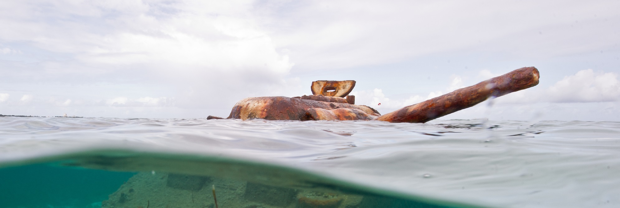
After the beaches were secured, support groups landed on the beachheads to facilitate the massive unloading of supplies. The post-invasion landscape they witnessed was grim; disabled LVTs and boxes of c-rations were scattered across the beach. Bodies of dead Marines that had not been recovered bobbed in the surf. “The leaves on battered trees and underbrush were covered with a fine, gray dust,” wrote former Naval Construction Battalion (Seabee) commander David Moore. “This whole scene gave an eerie feeling of war” (Moore 2002).
On the evening of D-Day, Seabees were ordered to launch floating causeways that were held in the LSTs (Landing Ship, Tanks). Throughout the night, the Seabees maneuvered the various pieces through the channel and assembled them at the Chalan Kanoa beachhead. By daybreak supplies were being unloaded from landing craft. Other craft towed pontoon sections that were made into floating piers to unload supplies. Pontoon barges were used to haul ammunition. While vital to the continued success of the U.S. operation on Saipan, unloading supplies and ammunition from barges on the beachhead became monotonous as combat moved farther inland. This “grueling mission of moving ammunition and other supplies to the beach…became a routine of eating bland c-rations and sleeping on the barge for a boring 54 days of blazing sun or miserable rain,” remembered one Seabee who served at Saipan. “The Coxswain often grumbled: it is noble to suffer. We [the Seabees] were granted the undistinguished title, ‘Bastards of the Beaches’” (Moore 2002). There were nevertheless many soldiers on the mainland that would have traded places with the Seabees. Japanese attempts to call in reinforcements from neighboring islands were fruitless, but they continued to fight with resolve.
Admiral Kakuta continued sending reconnaissance aircraft from various bases to locate Task Force 58. With each mission U.S. carrier air patrols shot down one plane after the other; it is reported that Hellcats scored 23 kills out of 31 claims (Tillman 2005:98). Carrier strikes against Saipan continued from 15 to 18 June. Planes from TF 58 carriers sank the auxiliary submarine chasers Cha 54 (15 June) and Cha 56 (17 June) at Rota, and the guard boat Marudia Maru on 17 June near Saipan.
By 17 June nearly 50,000 U.S. troops and a large amount of artillery were on Saipan’s western beaches (Dyer 1969:910). With tanks and artillery the Marines overcame Japanese resistance at Chalan Kanoa and Aslito Airfield. By 18 June the 4th Marine Division reached the east coast and started north.
On 18 June, the Japanese forces attempted a daring counter-landing from their tattered navy base at Tanapag Harbor. Japanese infantrymen were hastily loaded onto 35 barges and sent southward from Garapan toward the U.S. landing beaches. In route, the destroyer Phelps, with a contingent of landing craft gunboats (LCI-G) and amphibian tractors (LVT-A) intercepted them, destroying many and deterring all – 13 were sunk (www.ibiblio.org/hyperwar/USN/USN-Chron/USN-Chron-1944.html).
A larger-scale encounter played out in the Philippine Sea between 19 and 20 June when the U.S. Navy defeated the Imperial Japanese Navy (IJN) in what was known as the “Great Marianas Turkey Shoot.” In the meantime, the U.S. secured Aslito Airfield and the southern reaches of the island and prepared the northward fight (Crowl 1960; Rottman 2004a).
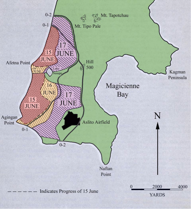
On 22 June, the 4th Marine Division cut across the island to the eastern shoreline, while the 2nd Marine Division secured the western coastline north of Chalan Kanoa to the base of Mt. Tapotchau. The 2nd and the 4th Marine Divisions now formed a line from Chalan Kanoa to Magicienne Bay and prepared to move north. General Holland Smith, USMC, knowing that the 2nd and 4th Marine Division’s lines were thin, ordered the 27th Army Infantry Division to enter the front lines between the 2nd and the 4th Marine Divisions on 22 June at a place called Death Valley (Dyer 1969:916). At the same time, the 29th Marine Regiment, 2nd Marine Division fought up the cave-pocked north face of Mt. Tapotchau (1,554-foot) with success coming on 27 June. The Kagman Peninsula was taken by the 4th Marine Division on the same day, and the 27th Infantry Division gained a foothold on “Purple Heart Ridge.” After ten grueling days of fighting, the U.S. troops gained high ground and could begin fighting downhill.
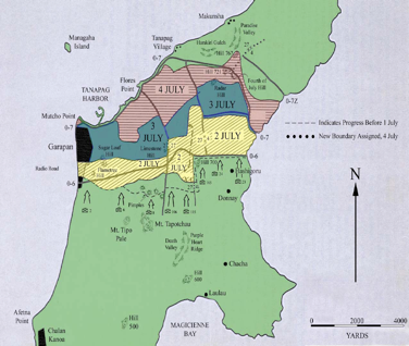
More gruesome scenes followed in the battle as June became July and U.S. troops pushed deeper into the island of Saipan. Garapan was secured on 3 July and the Tanapag seaplane base on 4 July. On 6 July, the Japanese staged their last massive banzai charge ordered by Lieutenant General Saito. The attack began two kilometers north of Tanapag in Matansa Village where Japanese troops assaulted several U.S. battalions (Russell 1994:24). Their efforts proved unsuccessful and thousands of Japanese soldiers lost their lives and hundreds of U.S. soldiers were killed (Rottman 2004a:68). Just prior to the banzai attack, Lieutenant General Saito committed ritual suicide by plunging a samurai sword into his stomach (Thompson 2002:30). After Saipan, Japanese commanders deemed such suicidal charges as wasteful. Rarely effective, they were not used in later battles. Through mountainous terrain, tropical conditions, and intense resistance, U.S. forces reached the northern end of Saipan at Marpi Point on 9 July 1944 (Crowl 1960; Rottman 2004a). Saipan was officially declared secure at Holland Smith’s headquarters in Chalan Kanoa at 10:00am (Hoyt 2000:404; Morrison 1968:338).
The Aftermath of the Battle of Saipan
The loss of life during the Battle of Saipan was tremendous. Approximately 3,426 of the 67,451 U.S. troops who participated in the battle were killed or reported missing in action. Four times this number were confirmed wounded. Japanese losses were far greater. Of the approximately 31,629 Japanese troops who participated in the battle, 29,500 were lost (Rottman 2004b). Japanese sources, however, estimated the total number killed on Saipan to be well over 40,000 (Bulgrin 2005). Additionally, 14,560 civilians were placed in internment camps (including 1,173 Koreans) and it is estimated that 22,000 civilians committed suicide (including Japanese, Koreans and native islanders) (Willmott 1999:147). Civilians on Saipan were afraid of being imprisoned and tortured by the U.S., thus a vast number committed suicide, some with children in hand.
The long-fought and costly victory at Saipan, the fiercest of the three major battles in the Marianas, was politically and militarily decisive. U.S. successes in the opening two weeks of the battle induced Japanese Emperor Hirohito to attempt a diplomatic end to the war. When news of Saipan’s fall reached Japan, political pressure forced Prime Minister, War Minister, and Chief of Army General Staff Tojo Hideki and his cabinet, as well as navy officials, to resign (Rottman 2004a).
Equally as important to the decisiveness of the victory at Saipan was the island’s proximity to Japan. This was also true of Guam and Tinian. The Mariana Islands were ideal for the development of bases for long range B-29 bombers that were capable of reaching the Japanese mainland. On Saipan, the U.S. wasted no time in developing these bases. Aslito Airfield was renamed Conroy Field and then Isley Field. By December 1944, it was used as the main operating field on the island. Two new airfields, Kobler Field and another at Kagman Peninsula, were also built at this time. The seaplane base at Flores Point was rebuilt and improvements were made to the Marpi Point airfield.
The capture of Saipan and the Mariana Islands paved the road for more decisive battles at Okinawa and Iwo Jima. Together, the great sacrifices of these and other battles of the Pacific War gave U.S. military planners an impression of what could be expected from an invasion of the Japanese mainland. Plans for such an invasion were in the making when the decision was made to drop the atomic bombs on Hiroshima and Nagasaki, resulting in the surrender of the Japanese Empire and the conclusion of WWII.
Post-War
The invasion of the islands by U.S. forces in the summer of 1944 left devastation in its wake. The battle resulted in high casualties on both sides and the destruction of much of the islands. The U.S. commanders and officers were specially selected and trained to improve the welfare of the newly liberated civilians and maintain public order. Distinctions were quickly made between the various island ethnic groups; most were treated as innocent victims or, in the case of Japanese civilians, rounded up and treated as harmless enemies.
Saipan and Tinian became forward bases for the offensive, with airstrips and a variety of related government buildings. A garrison force was established on Saipan with antiaircraft guns and the 318th Fighter Group to defend the island from Japanese aircraft. Seabees began cleaning up the mess, continuing to develop the airport, building emergency structures, providing potable water and sanitation to protect the troops from disease. Salvage and recovery operations were also a priority – shipping lanes needed to be cleared of obstructions and usable materials needed to be salvaged for the re-build. As a result several U.S. salvage ships operated in the region and around Saipan.
For two years following the war, the status of Micronesia was in limbo. From 1945 to 1947 the islands continued under U.S. military occupation. Under the interim U.S. military government, Indigenous populations were relocated back to their homes and farms. Efforts were immediately made to repatriate all Japanese and Okinawan civilians.
The northern islands came under trusteeship status in 1947. In 1948, the Central Intelligence Agency (CIA) closed off half of Saipan to islanders and outsiders, using the northern part of the island for covert military maneuvers. The end of WWII left a power vacuum that was being filled by communism; the Cold War objectives of the CIA’s covert facility on Saipan were to thwart communist expansion. The island’s remoteness and control by the military made it an ideal base for this training and the Naval Technical Training Unit (NTTU) was established. “The primary mission of the Saipan Training Station [was] to provide physical facilities and competent instructor personnel to fulfill a variety of training requirements including intelligence tradecraft, communications, counter-intelligence and psychological warfare techniques. Training [was] performed in support of CIA activities conducted throughout the Far East” (Lansdale 1961:649).
References
(This history was adapted from after SEARCH, Inc. 2008a)
Chapin, J. C. 1994 Breaching the Marianas: The Battle for Saipan. Marines in World War II Commemorative series. History and Museums Division, Headquarters, US Marine Corps, Washington, D.C.
Crowl, P. A. 1960 US Army in World War II: The War in the Pacific: Campaign in the Marianas. Office of the Chief of Military History, Department of the Army, Washington, DC.
Denfeld, D. C. 1992 Japanese World War II Fortifications and Other Military Structures in the Central Pacific. Northern Mariana Islands Division of Historic Preservation, Saipan.
Department of Community and Cultural Affairs, Division of Historic Preservation 2004 Pacific Preservation: The Commonwealth of the Northern Mariana Islands 2004-2008 State Historic Preservation Plan. Department of Community and Cultural Affairs, Saipan.
Dyer, G. C., Vice Admiral, USN (Retired) 1969 The Amphibians Came to Conquer: The Story of Admiral Richmond Kelly Turner. Washington, D.C.
Farrell, D. 2009 Operation Tearaway and Tattersalls. In Maritime History and Archaeology of the Commonwealth of the Northern Mariana Islands, edited by T. Carrell, pp.269-343. Submitted to the CNMI Department of Community and Cultural Affairs, Division of Historic Preservation. Ships of Exploration and Discovery Research, Inc., Texas.
Goldberg, H. J. 2007 D-Day in the Pacific: The Battle of Saipan. Indiana University Press, Bloomington, IN.
Hoyt, Edwin P. 2000 How They Won the War in the Pacific: Nimitz and his Admirals. The Lyons Press, Guilford, CT.
Kauffman, D. 1986 The UDTs Come of Age at Saipan. In The Pacific War Remembered: An Oral History Collection, edited by J. Mason. Naval Institute Press, Annapolis, MD.
Lansdale, E. G. 1961 Excerpts from Memorandum from Brig. General Edward G. Lansdale, Pentagon expert on guerrilla warfare, to General Maxwell D. Taylor, President Kennedy’s military advisor on Resources for Unconventional Warfare, SE Asia. July 1961. The Pentagon Papers, Gravel Edition, Volume 2:643-649.
Lodge, O.R. 1954 The Recapture of Guam. Reprinted 1998. Awani Press, Fredericksburg, Texas.
Moore, D. 2002 The Battle of Saipan—The Final Curtain. Electronic document, http://www.battle ofsaipan.com/seabee.htm, accessed October 29, 2008.
Morrison, S. E. 1968 History of the United States Naval Operations in World War II, Vol. Viii, New Guinea and the Marianas: March 1944-August 1944. Little, Brown and Company, Boston, MA.
Okumiya, M. and J. Horikoshi 1956 Zero: The Story of Japan’s Air War in the Pacific- as seen by the enemy. Ibooks, New York, NY.
Rogers, R. F. 1995 Destiny’s Landfall: A History of Guam. University of Hawaii Press, Honolulu, HI.
Rottman, G. L. 2004a Saipan & Tinian 1944: Piercing the Japanese Empire. Osprey Publishing, Oxford, UK.
Rottman, G. L. 2004b US World War II Amphibious Tactics: Army & Marine Corps, Pacific Theater. Osprey Publishing, Oxford, UK.
Russell, S. 1984 From Arabwal to Ashes: A Brief History of Garapan Village; 1818 to 1945. Micronesian Archaeological Survey Report Number 19, Department of Education, Commonwealth of the Northern Mariana Islands, Saipan, MP.
Russel, S. 1994 Operation Forager: The Battle for Saipan. Division of Historic Preservation, Saipan, Commonwealth of the Northern Mariana Islands Saipan, MP.
SEARCH, Inc. 2008a Archaeological Survey of Lagoons of on the West Coast of Saipan, Commonwealth of the Northern Mariana Islands. Submitted to the CNMI Department of Community and Cultural Affairs, Division of Historic Preservation. Southeastern Archaeological Research, Inc., FL.
Spector, R.H. 1984 Eagle Against the Sun: The American War with Japan. Viking Penguin, Inc., New York, NY.
Tillman, B. 2005 Clash of the Carriers: The True Story of the Marianas Turkey Shoot of World War II. NAL Caliber, New York, NY.
Thompson, C. 2002 The 25 Best World War II Sites: Pacific Theater. Greenline Publications, San Francisco, CA.
Tillman, B. 1999 TBF/TBM Avenger Units of World War 2. Osprey Publishing, Oxford, UK.
Wheeler, R. 1993 A Special Valor: The U.S. Marines And The Pacific War. Meridian, New York, NY.
Willmott, H.P. 1999 The Second World War in The Far East. Weidenfeld & Nicolson, London, UK.