“Princeville residents were forced to rethink their future last year (1999) after Hurricane Floyd when the Tar River Breached a high levee, reached a record forty-three crest, and submerged the town for nearly two weeks”.
-From Reclaiming Sacred Ground by Victor Blue.
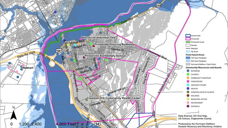
Due to the town’s position along the river, Princeville has experienced several major floods in its history. Even though the Army Corps. Of Engineers did place a levee in the Tar River. Unfortunately, when Hurricane Floyd made landfall in 1999, the flood waters overcame the levee and flooded the town for eleven days (US Army Corps of Engineers 2014). There have been several attempts to try and move the residents of Princeville further from the river and leave the historic area, but the residents have decided to stay in the historic town. After another major flooding from Hurricane Matthew in 2017, authorities vowed to work with the residents to find a way preserve the historic town while protecting the residents (Jarema 2017). The map shown above is from the Department of Public Safety of North Carolina. It highlights different features in Princeville and surrounding areas. It also shows the flood plains created by previous hurricanes.
The aforementioned article by Victor Blue also describes how the floods have obscured the town’s past and diminished the capacities of researchers to gather information. Storm surges annually threaten the towns few remaining historical artifacts, especially highly significant areas such as cemeteries. High floodwaters have caused caskets to resurface several times in the past, with boat crews and local volunteers having to conduct emergency “rescues” to re-intern the coffins (Blue 2000). More information can be found under the “Historical Buildings and Cemeteries” tab.
Sources:
Blue, V. E. (2000). Reclaiming Sacred Ground: How Princeville is recovering from the flood of 1999. NC Crossroads, 4(3). Retrieved January, 2019.
US Army Corps of Engineers
2014 Princeville, North Carolina Flood Risk Management Integrated Feasability Report and Environmental Assessment: Draft Report. Princeville, Edgecombe County, North Carolina. https://www.edgecombecountync.gov/Hurricane%20Matthew/Princeville%20Levee%20Integrated%20Report%20FINAL%20Draft%20-%2003%2012%2014.pdf
Jarema, Julia
2017 Design Teams Gather to Plan Princeville’s Future: Residents Urged to Get Involved. North Carolina Department of Public Safety. Raleigh, NC. https://www.ncdps.gov/design-teams-gather-plan-princevilles-future