Site Name/Number: Shiloh Landing, Log Canoe Site# TRR0008
Location (Description and Coordinates):
Entrance to Shiloh Landing at Shiloh Mills Public Fishing Area, near intersection of Shiloh Farm Rd. and NC Hwy 258, 2 miles northeast of Tarboro, NC. N 35° 54′ 23.25″, W 77° 29′ 37.91″.
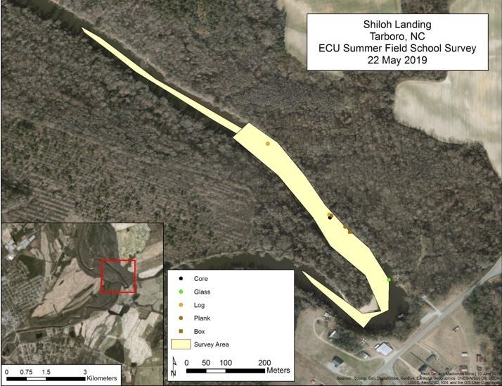
Site #TRR0008 (Log Canoe), is located approximately 509.2 meters upriver from the landing at a 142.55° heading, at the mouth of the second creek: N 35° 54′ 37.79″, W 77° 29′ 49.26″. Coordinates given by UAB for TRR0009, the Andrew Lanier Log Canoe recorded in 1999: N 35° 54′ 26.32″, W 77° 29′ 46.80″.
Date Dived/Inspected: 22 & 30 May 2019
Weather on date of Inspection (tide, etc.):
22 May – Sunny, High Temp. 81°, Winds 6.93mph from NE
30 May – Sunny, High Temp. 97°, Winds 14.76mph from SW
Depth:
22 May (at gauge in Tarboro, NC) – 3.08 ft.
30 May – 2.42 ft.
Visibility/Current:
Visibility approximately 2-3 ft. for both 22 and 30 May;
22 May (at gauge in Tarboro, NC) at 9:00am – 0.498 kilo cubic feet per second (KCFS)
30 May at 9:00am – 0.296 KCFS
Environment (general and biological)
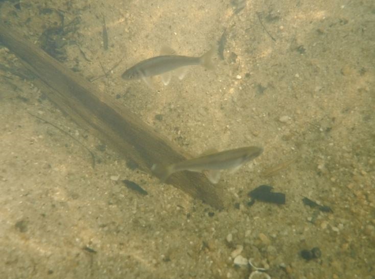
The Tar River is freshwater with freshwater creeks feeding into it. The depth ranged from a few inches at the shoals to 5-6 ft. in the deeper areas; the ox bend was around 20 ft. deep. Cyprus trees and long pine trees were thick along the shoreline. A brown river snake was spotted along the shoreline, and small fish, mostly fathead minnows (Pimephales promelas), were abundant when researchers were disturbing the sediment.
Bottom Composition (sediment description, slope, topography, etc.):
Sediment type varied from soft fine sediments in the creeks and along the banks to medium on the cut bank and point bars to medium-coarse in the deeper areas and farther upstream. Natural Resources Conservation Service (NRCS) defines the soil as Congaree (Shellbluff) silt loam and Tarboro loamy sand (NRCS 2019). Mussels and shell fragments were also present, especially near the banks.
Brief Historical Context:
Evidence for Native American reliance on the Tar River basin for hunting, transportation, and social contact dates to the Woodland period (Wyllie 2012:59). Native Americans used shallow dugout canoes to efficiently navigate the river, but the canoes had limited cargo capacity (Wyllie 2012:65). European settlers adapted dugout canoes to improve stability and increased carrying capacity, leading to the use of plantation schooners, periaugers, and sloops from the 17th to 19th century (Wyllie 2012:67, 69). Shallow waters and prevalent snags prevented the use of most vessels other than those with flat bottoms on the Tar River, especially for use in cargo transportation, both of goods and humans (Wyllie 2012:68).
Shiloh Landing was used for offloading purchased slaves to Edgecombe County in the Antebellum period (Adrianzen et al. 2014:1). The nearby Shiloh Mill served as a distribution center for local farmers who needed to purchase additional slaves. The landing became a center for spiritual activities for freed slaves who stayed in the Tarboro-Princeville area (Adrianzen et al. 2014:7). More recently it has been used as a dumping ground for farm equipment, especially because of the deep waters at the ox bend. Locals frequent the pier for fishing and the pool for swimming.
Methods of Investigation:
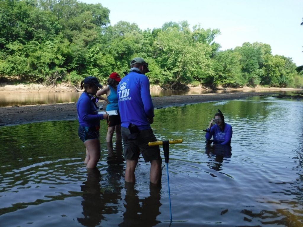
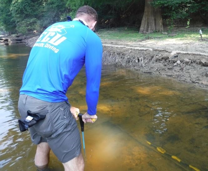
Good visibility facilitated a line survey using snorkel upriver, and visual survey using canoes. Strong current and sporadic deep waters in some areas prevented employing a line survey technique with regular intervals along a tape. Team members generally stayed within arm’s length in pairs along the eastern bank surveying upstream, and the western bank surveying downstream. When cultural material was found, the team probed the surrounding areas to determine extent. The team hand fanned around imbedded artifacts in order to photograph, measure, and draw in situ. Smaller artifacts were photographed, measured, and drawn above water, then placed back in their original location. All cultural material found was recorded as a GPS waypoint. GPS units also tracked the extent of the survey.
General Description (of site):
The site surveyed extended about 510 meters northwest of the landing. A few historic artifacts were located, but scattered along the eastern bank of the river without regular spatial patterning to indicate their association. Local knowledge indicates that the ox bend likely contains many pieces of derelict farming equipment because of its use as a dumping ground.
Features (Natural and Cultural):
A boardwalk provides access to the fishing pier from the parking lot and launch area along the southeastern edge of the ox bend. An automatic pump for irrigating the nearby fields is about 60 meters northwest of the launch area. Two creeks empty into the east bank of the river about 40 meters and 485 meters northwest of the launch area, respectively. The ox bend is typical with a deep pool opposite a point bar in the sharp curve of the river. On the west bank of the river around the ox bend from the launch area is a house, built on the edge and in danger of sliding into the river. The bank on the west side of the bend is very steep and tall, and constantly eroding. Along the banks of the river upstream from the launch area, there are several snags of naturally felled logs and potentially culturally modified logs.
Artifacts:
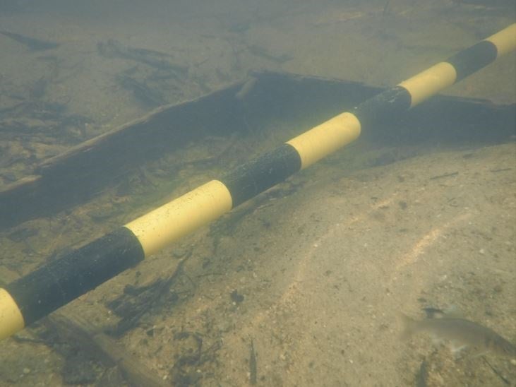
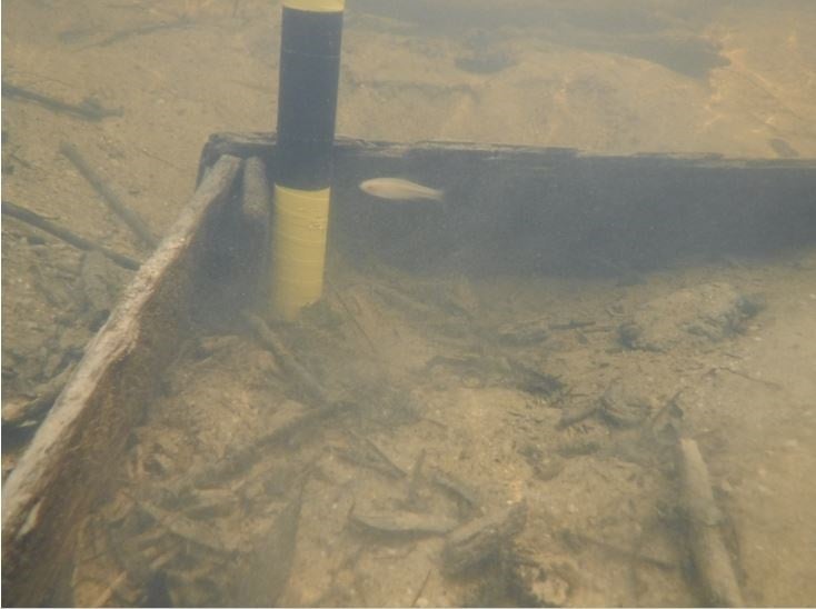
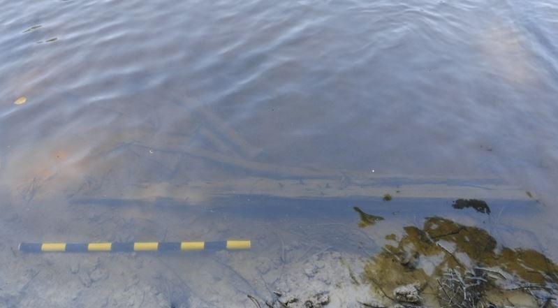
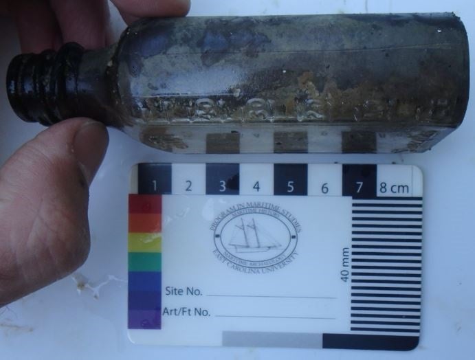
The survey found four artifacts. A wooden box (N 35° 54′ 29.5″, W 77° 29′ 42.0″) was labeled as SHI1 on 22 May. A smaller group returned on 30 May to record the box in more detail. Mackenzie Mirre detailed in her internal report that “[t]he exposed boards of the box measure 4.3m in length and .22m tall on the northern side and .65m on the southern. Both sides have evidence of breaks at the ends of the exposed boards. The western edge of the box is .51m and .20m tall. All boards are .012m thick. There is a .07m wide strake inside the northwestern corner of the box. The same corner is attached with iron fasteners. Two possible floor boards, one with possible fastener, lay just to the north of the northeastern edge” (Mirre 2019). Other artifacts found on 22 May include: a plank with fasteners (N 35° 54′ 29.9″, W 77° 29′ 42.4″) labeled as SHI2. A notched plank with fastener (N 35° 54′ 30.8″, W 77° 29′ 43.5″) labeled as SHI4 and a small brown glass bottle with screw top (N 35° 54′ 25.5″, W 77° 29′ 38.7″) labeled as SHI5. This survey was unable to locate TRR0008 or TRR0009, the log canoe recorded by UAB in 1999 as 4.98m long and .84m at the widest with an apparently round cross section (UAB 1999).
Human or Environmental Impacts:
The steep western bank has the potential to further erode, obscuring some artifacts in the ox bend. Because the site is also a popular fishing and swimming location, human activities could interfere with the preservation of artifacts in and around the bend. Maintaining the Shiloh Mills Public Fishing Area will lead to the continued human interaction with the site.
Potential Threats:
Human interference with the site will be a potential threat for as long as the public fishing area is maintained. People could either inadvertently or purposefully disturb artifacts and general preservation by removing materials from the river. The site could also be impacted by natural threats, such as flooding or shore erosion.
Associated Artifacts Onshore or Nearby (i.e. museums, private collections):
No known associated artifacts in museums or otherwise.
Associated References:
Adrianzen, Josue, Shelton Current, Andrew Flinchum, and Molly Williams
2014 Shiloh Landing: Final Report and Implementation Plan. Practicum, Department of Public Policy, UNC-Chapel Hill, Chapel Hill, NC.
Mirre, Mackenzie
2019 Shiloh Landing Box Description. Site report for East Carolina University 2019 Summer Field School, Department of History, East Carolina University.
Underwater Archaeology Branch
1999 TRR0009 Archaeological Site Forms, Andrew Lanier Canoe. Manuscript, North Carolina Underwater Archaeology Branch, Kure Beach, NC.
Natural Resources Conservations Service (NRCS)
2019 Web Soil Survey. <https://websoilsurvey.nrcs.usda.gov/app/WebSoilSurvey.aspx>. Accessed 14 June 2019.
Wyllie, Elizabeth
2012 Defining Eastern North Carolina Upriver Steamboats Through Tar River Archaeology and History. Master of Arts Thesis, Department of History, East Carolina University. University Microfilms International, Ann Arbor, MI.
Future Research Potential:
The bend was not surveyed because the original objectives were to locate the log canoe farther upstream. Additionally, the deep, turbulent water with hazardous debris was a safety concern. Since the bend has been a place where farmers have disposed of their equipment, the potential for understanding the progression of farming equipment use in the Tar River Basin. Future researchers should exercise caution if researching the bend.
Future Public Outreach Potential:
There has recently been a movement to protect Shiloh Landing’s African American heritage. Surveying for any associated artifacts would provide a tangible link to a community lacking in tangible history.