Site Name/Number:
Tar River Navigation Lock; TRR0026
Location (Description and Coordinates):
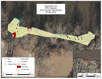
Coordinates: 35°36’54.834”N, 077°21’19.05”W using WGS 1984 in reference to the upright nearest shore on the westernmost section of the site. The lock was built on the south bank of the river, and is located roughly 50 meters west of the Greenville Greenway behind the Greenville dog park. A pavilion and historic plaque mark the location above the river. The site’s total extent is along roughly 70 meters of riverbank and extends at least 6 meters into the river, although more features may be located deeper.
Date Dived/Inspected:
5/21/2019, 5/30/2019
Weather on date of Inspection (tide, etc.):
May 21 (Tuesday): Sunny, 90°, river current mean velocity ~.9 feet per second. The tide discharged was 941 cubic feet per second, gauge height 3.61 feet.
May 30 (Thursday): Sunny, 99°, river current mean velocity ~.22 feet per second. The tide discharged was 261 cubic feet per second, gauge height 4.12 feet.
All measurements were taken at noon in Greenville, Town Commons, NC (USGS Water Resources). The site was visited during extremely low water levels due to lack of rainfall.
Depth:
The site runs from shore to a depth of half a meter before a ledge roughly three meters from shore. After the ledge the depth drops another two or three meters. The site continues deeper into the river, and further investigation and survey using scuba gear is possible.
Visibility/Current:
Low to fair visibility, around one to one and a half meters.
Environment (general and biological):
No water samples were taken. The flora consists of loblolly pine, swamp chestnut oak, laurel oak, cherrybark oak, water oak, willow oak, green ash, red maple, bald cypress, and sweetgum (UNC Institute for the Environment). Underbrush is thick with a lot of poison oak and poison ivy. Wildlife include king snake, common snapping turtle, and fish.
Bottom Composition (sediment description, slope, topography, etc.):
The bottom of the shore side is mostly mud and clay, the bottom of the deep side is unknown. The low level of the water has exposed the underside of the bank which exposed several root systems.
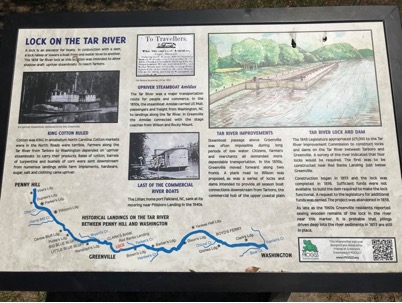
Brief Historical Context:
The construction of the locks began in 1853 and the estimated cost was $74,396 (equivalent to $2,426,148.57 today). The project was to consist of four locks and four dams spread from the Tarboro Bridge to just below Greenville, NC (The North-Carolina Standard: Nov. 9, 1853). The locks were to assist larger vessels in traveling up and down the Tar River during low water levels by keeping “a minimum of three and one-half feet of water in the channel as far inland as Tarboro at all times of the year” (Cox 1989:53). The construction project, however, was unorganized, and proceeded without a general plan. The lock below Greenville was completed in September 1856, and a dam was recommended. Unfortunately, the funds had been exhausted, and progress stopped. The lock itself turned into a potential hazard in the river. Even if the dam had been built, the system was set to failure “one part of the lock…has settled and rendered the gates unfit for use” (Lane et.al. 1858:2). An old fisheries map of the Tar River notes the lock below Greenville (Bureau of Fisheries 1906). The construction status of the other three locks and dams is unknown. A brick patio, marked in the site map, may have been a historic building or house along the riverbank.
Methods of Investigation:
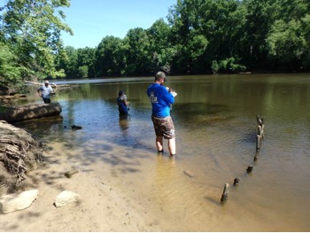
Photographs were taken with Fujifilm FinePixXP80 and FujifilmFinePixXP130 digital underwater cameras; features and artifacts were photographed with a meter scale and an 8cm scale, respectively. The site can be divided into two sections, an east and a west section, and photographs were taken of each. The western section had clear features that protruded from the water, and photographs were taken of these and measured with a meter scale. All removable artifacts were recorded then placed back in their original locations.
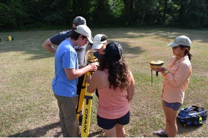
A Real Time Kinetic (RTK) unit was utilized on the site. The RTK unit was TOPCON, Hyper V model, with tablet FC5000. The height of the base unit was set at 1.52 meters, and the height of the rover pole was set at 2 meters. The antenna in the base station was set at a 5° slant. The elevation of the base unit was -28.403 meters relative to sea level, the projection was set in UTM North Zone 17, and the distance precision 0.123. The points were labeled using a general one or two word description. Labels included VERTICAL PILING, BRICK, BRICK CLUSTER, BRICK PATIO, WATER EDGE, BANK EDGE, SLEEPER, CABLE, FASTENER, FASTENER HOLE, and TREE. 175 points were taken in total. The RTK unit was set to fixed, floating, and DGPS, which made some points more accurate than others. The points gathered were compared to the GPS points taken in the same spots, the results of which are shown in the site map.
The eastern section was mapped and surveyed with RTK on 30 May. Two team members discovered by a general survey the same day that the site continues east past the end of the original search area as well as farther north into the river. This section was felt by hands and feet, but there was no visual confirmation due to the lack of snorkel equipment and good visibility. Tyler McLellan and Jeremy Borrelli also swam around the section north of the bottom drop. While in this section, a piece of timber floated up from the west side of the beam furthest east. This section was carried to shore, measured, and photographed, then redeposited on shore under cypress roots.
General Description (of site):
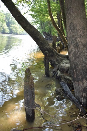
The site is located on the south bank of the Tar River, just north of the Greenville dog park. The site runs east to west, with the western section separate from the eastern section by about 24 meters. No features were identified during this survey in the break between the two sections, although may be present in deeper water. The western section comprises of a series of 18 uprights standing vertically from the river bottom, and a nineteenth laying on its side. The uprights form a curved ‘L’ shape, the shorter side running perpendicular from the shore northward towards the center of the river. Of the eight perpendicular uprights, the four farthest from the bank are connected by a series of horizontal metal braces. The ninth piling from the shore side leads into a curve that extends farther west with the remaining 10 pilings. This shape is displayed in the RTK readings. The points that are marked as ‘vertical pilings’ on the western side of the map form a curve that leads away from the bank and curves to point north. On the river side of these uprights, the bottom drops off several feet, indicating a vertical structure. This combined structure may have been a section of dock or pier.
Just east of this ‘L’ formation begins the twenty-four meters of bank that lack features. Farther east along the bank are another set of 10 uprights that are larger and spread farther apart compared to the first set. These uprights run parallel to the bank, with some connected by metal cables, essentially pointing to the eastern section of the site.
The eastern section has several sleeper boards that run into the water, running north to south, as shown in the site map. Four of these boards were found running north/south, with another board running perpendicular across under them. This board runs parallel to shore and the bottom drops over six feet on the river side of the board. A sixth board runs at an angle from the shoreline, where a large metal spike protrudes from the end. The board furthest to the east extends several meters into the river, partially covered halfway by submerged root systems. This board was not seen but rather felt. Boards running at angles from this large piece were also felt. A large cypress tree marks the furthest extent on the east side of the study area. A rough sketch of the eastern section that was surveyed can be viewed in. This may have been the lock itself. Features could be observed further east that were not examined. The bank is steep, and the eastern section of the site is densely covered in vegetation.
Features (Natural and Cultural):
A marking natural feature is a cypress tree with a large exposed root system that marks the easternmost extent of the survey area. The cultural features include sleeper boards that run along the ground, either above the surface or submerged. Other features include uprights and steep human-made drop offs that drop straight down.
Artifacts:
Artifacts were photographed along with an 8cm scale on the eastern section. These include a glass apothecary bottle, an iron spike, several other broken glass bottles, ceramic, various pieces of trash, bricks, brick clusters, pieces of concrete, and a large piece of sleeper board that had broken off from the center of the eastern section of the site. The bricks and concrete may have come from the area of the brick patio, as many of the large brick clusters are located within 15 meters to 20 meters of the patio. The trash is modern, comprising mostly of beer cans. The piece of ceramic is of unknown origin, but the iron spike is most likely from the lock itself. The apothecary bottle is believed to be more historic, but the origins are unknown.
Human or Environmental Impacts:
Environmental impacts include the current and erosion. Human impacts include fishing and boating, as well as littering on or around the site.
Potential Threats:
The river’s current and water level changes may bury or erode the site, decreasing access to potential researchers. Littering and fish line entanglement also threaten the integrity of the site. Further, due to its location and accessibility during periods of low water levels, souvenir collectors may be able to access the site.
Associated Artifacts onshore or nearby (i.e. museums, private collections):
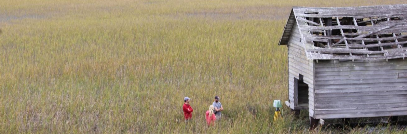
An educational plaque on the riverside of the Greenway bike trail informs the public of the site below with a brief description and history of the locks.
Associated References:
Bureau of Fisheries
1906 Map of Tar River, NC: Showing Approximate Location of Seines Fished for Shad in 1906. North Carolina Maps https://dc.lib.unc.edu/cdm/ref/collection/ncmaps/id/1064. Accessed 14 June 2019.
Cox, James M.
1989 The Pamlico-Tar River and its Role in the Development of Eastern North Carolina. Master’s Thesis, Department of History, East Carolina University, Greenville, NC.
Lane, Wm. K. B.C. Douthit, T. Sparrow, John F. Hutchins, John S. Dancy, Thomas Cox.
1858 Report of the Joint Select Committee on the Improvement of Tar River. Doc. No. 69, Holden and Wilson, NC.
Thompson, Beverhout W.
1853 Improvement of Tar River: Report. The North Carolina Standard 9 November, Raleigh, NC.
University of North Carolina Institute for the Environment
2014 Natural Environments of the Tar-Pamlico River Basin, adapted from Ecoregions of North Carolina and the Tar-Pamlico River Basin Plan 2010. University of North Carolina, pp.1-3. Chapel Hill, NC.
United States Geological Services
2019 USGS 02084000 Tar River at Greenville, NC. USGS Water Resources, USGS. https://waterdata.usgs.gov/nwis/uv?cb_00045=on&cb_00060=on&cb_00065=on&cb_72255=on&format=gif_default&site_no=02084000. Accessed 6/12/2019.
Future Research Potential:
Much of the eastern section of the site needs to be properly measured and mapped out using snorkel or scuba gear, as well as in deeper water farther out in the river. The fullest extent of the locks in the area is unknown. The site’s location in Greenville eases access for potential researchers. Further, the site can be compared to other lock systems of the mid-1800s. The significance of the brick patio as well as the bricks and brick clusters that surround the site can be researched for identification, time period, ownership, and relation to (or protrusion of) the lock.
Future Public Outreach Potential:
The site can be used as part of a larger historic trail of historic Greenville.